shakedown.social is one of the many independent Mastodon servers you can use to participate in the fediverse.
A community for live music fans with roots in the jam scene. Shakedown Social is run by a team of volunteers (led by @clifff and @sethadam1) and funded by donations.

Administered by:

Server stats:

261
active users

#geophysics

2 posts2 participants0 posts today

Io’s Missing Magma Ocean

In the late 1970s, scientists conjectured that Io was likely a volcanic world, heated by tidal forces from Jupiter that squeeze it along its elliptical orbit. Only months later, images from Voyager 1’s flyby confirmed the moon’s volcanism. Magnetometer data from Galileo’s later flyby suggested that tidal heating had created a shallow magma ocean that powered the moon’s volcanic activity. But newly analyzed data from Juno’s flyby shows that Io doesn’t have a magma ocean after all.

The new flyby used radio transmission data to measure any little wobbles that Io caused by tugging Juno off its expected course. The team expected a magma ocean to cause plenty of distortions for the spacecraft, but the effect was much slighter than expected. Their conclusion? Io has no magma ocean lurking under its crust. The results don’t preclude a deeper magma ocean, but at what point do you distinguish a magma ocean from a body’s liquid core?

Instead, scientists are now exploring the possibility that Io’s magma shoots up from much smaller pockets of magma rather than one enormous, shared source. (Image credit: NASA/JPL/USGS; research credit: R. Park et al.; see also Quanta)

Ponding on the Ice Shelf

Glaciers flow together and march out to sea along the Amery Ice Shelf in this satellite image of Antarctica. Three glaciers — flowing from the top, left, and bottom of the image — meet just to the right of center and pass from the continental bedrock onto the ice-covered ocean. The ice shelf is recognizable by its plethora of meltwater ponds, which appear as bright blue areas. Each austral summer, meltwater gathers in low-lying regions on the ice, potentially destabilizing the ice shelf through fracture and drainage. This region near the ice shelf’s grounding line is particularly prone to ponding. Regions further afield (right, beyond the image) are colder and drier, often allowing meltwater to refreeze. (Image credit: W. Liang; via NASA Earth Observatory)

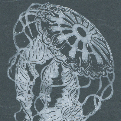
Non-Newtonian Effects in Magma Flows

As magma approaches the surface, it forces its way through new and existing fractures in the crust, forming dikes. When a volcano finally erupts, the magma’s viscosity is a major factor in just how explosive and dangerous the eruption will be, but a new study shows that what we see from the surface is a poor predictor of how magma actually flows within the dike.

Researchers built their own artificial dike using a clear elastic gelatin, which they injected water and shear-thinning magma-mimics into. By tracking particles in the liquids, they could observe how each liquid followed on its way to the surface. All of the liquids formed similar-looking dikes at a similar speed, but within the dike, the liquids flowed very differently. Water cut a central jet through the gelatin, then showed areas of recirculation along the outer edges. In contrast, the shear-thinning liquids — which are likely more representative of actual magma — showed no recirculation. Instead, they flowed through the dike in a smooth, fan-like shape.

The team cautions that surface-level observations of developing magma dikes provide little information on the flow going on underneath. Instead, their results suggest that volcanologists modeling magma underground should take care to include the magma’s shear-thinning to properly capture the flow. (Image credit: T. Grypachevska; research credit: J. Kavanagh et al.; via Eos)

Happy birthday to Danish #seismologist Inge Lehmann (1888 – 1993) who demonstrated that the Earth’s core is not a single molten sphere, but contained an inner solid core, in ‘36. She was a pioneer #womanInScience, a brilliant seismologist & lived to be 105.⁠

As she first postulated, the #earth has roughly 3 equal concentric sections: mantle, liquid outer core & solid inner core. The crust, on which we live is merely 🧵1/n

Let's talk about "#AI", #LLM, and #MachineLearning, which I don't put in quotes.
First, I am not anti-science, I am anti-JUNKscience and MARKETING, and there is a difference.
Why can I discuss a field I'm not in with some knowledge? I spent over 30 years in #geophysics, #SignalProcessing, and in #geology and #hydrology and #hydrogeology modelling. People doing this kind of work (along with #meteorology and #Climatology) are the progenitors of the current science. 1/

Our own @BaerbelW traveled to Vienna for this year's #EGU25 General Assembly of the @EuroGeosciences

Baerbel herself did a couple of presentations in Vienna:

* Examples of Skeptical Science successfully collaborating with other organizations so as to better reach shared goals, get more gain for less effort. With so much reward, we're eager to do more.

* How Skeptical Science translates our content into 29 different languages, the challenges of maintaining a polyglot presence. You may be able to help!

Baerbel also kept a daily journal. It's loaded with links to scads of intriguing information presented at the assembly by many researchers, with teasers and organized for easy access.

Post facto virtual attendance , distilled and at our fingertips. :-)

#geoscience
#geophysics
#ScienceCommunication

skepticalscience.com/egu25-per

Bifurcating Waterways

Your typical river has a single water basin and drains along a river or two on its way to the sea. But there are a handful of rivers and lakes that don’t obey our usual expectations. Some rivers flow in two directions. Some lakes have multiple outlets, each to a separate water basin. That means that water from a single lake can wind up in two entirely different bodies of water.

The most famous example of these odd waterways is South America’s Casiquiare River, seen running north to south in the image above. This navigable river connects the Orinoco River (flowing east to west in this image) with the Rio Negro (not pictured). Since the Rio Negro eventually joins the Amazon, the Casiquiare River’s meandering, nearly-flat course connects the continent’s two largest basins: the Orinoco and the Amazon.

For more strange waterways across the Americas, check out this review paper, which describes a total of 9 such hydrological head-scratchers. (Image credit: Coordenação-Geral de Observação da Terra/INPE; research credit: R. Sowby and A. Siegel; via Eos)

Energy Flow and Earth: How Earth Works by John A. Whitehead, 2024

This book shows how energy flow plays a major role in: plate tectonics; the formation of continents; ocean basins; and building mountains. Energy flow also produces and drives volcanos, Earth’s magnetic field, the wind belts, our weather, and ocean circulation.

Chapter abstracts:
link.springer.com/book/10.1007

@bookstodon
#books
#nonfiction
#geology
#geophysics
#EarthScience
#Earth
#energy

Arctic Melt

Temperatures in the Arctic are rising faster than elsewhere, triggering more and more melting. Photographer Scott Portelli captured a melting ice shelf protruding into the ocean in this aerial image. Across the top of the frozen landscape, streams and rivers cut through the ice, leading to waterfalls that flood the nearby ocean with freshwater. This meltwater will do more than raise ocean levels; it changes temperature and salinity in these regions, disrupting the convection that keeps our planet healthy. (Image credit: S. Portelli/OPOTY; via Colossal)

Reclaiming the Land

Lava floods human-made infrastructure on Iceland’s Reykjanes peninsula in this aerial image from photographer Ael Kermarec. Protecting roads and buildings from lava flows is a formidable challenge, but it’s one that researchers are tackling. But the larger and faster the lava flow, the harder infrastructure is to protect. Sometimes our best efforts are simply overwhelmed by nature’s power. (Image credit: A. Kermarec/WNPA; via Colossal)