Recent searches
Search options

#wx
123 posts23 participants2 posts today


#wx #NWS Active Weather Alerts https://www.weather.gov Short Range Forecast Discussion
NWS Weather Prediction Center College Park MD
335 PM EDT Fri May 30 2025
Valid 00Z Sat May 31 2025 - 00Z Mon Jun 02 2025
...A strengthening low pressure system will bring moderate to heavy rain
and gusty winds from the Ohio Valley to the Mid-Atlantic states this
evening into tonight, then to New England and the interior Northeast on
Saturday...
...Severe thunderstorms likely this evening for parts of the Mid-Atlantic
and the Southeast...
...Significant heat expected across interior California and portions of
the Southwest through Saturday...
A strengthening low pressure system will track across the no


#wx #NWS Active Weather Alerts https://www.weather.gov Short Range Forecast Discussion
NWS Weather Prediction Center College Park MD
400 AM EDT Fri May 30 2025
Valid 12Z Fri May 30 2025 - 12Z Sun Jun 01 2025
...A low pressure system will bring a round of moderate to heavy rain and
gusty winds from the Ohio Valley to the Mid-Atlantic states today then
across New England on Saturday...
...Severe thunderstorms possible later today for the Mid-Atlantic and the
Southeast...
...Heat risk expected to reach major level for interior California and
portions of the Southwest Friday and Saturday...
A low pressure system currently developing over the Midwest is forecast to
track across the northern


#wx #NWS Active Weather Alerts https://www.weather.gov Short Range Forecast Discussion
NWS Weather Prediction Center College Park MD
138 PM EDT Thu May 29 2025
Valid 00Z Fri May 30 2025 - 00Z Sun Jun 01 2025
...Dangerous heat expected in the Southwest Friday and Saturday...
...Excessive rainfall is constrained to the southern and eastern portions
of the country through Saturday...
The general flow pattern features a deepening upper level trough in the
East where temperatures will remain mild/become increasingly below average
for most areas, while ridging builds across the West and into the northern
Plains, bringing increasing heat/above average temperatures with time.
Record high temper


Continued thread

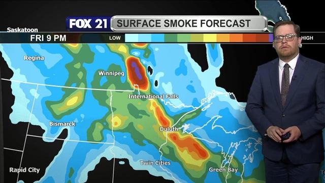
NORTHLAND FORECAST FOR MAY 30, 2025:
DISCUSSION: https://www.fox21online.com/weather/


NORTHLAND FORECAST FOR MAY 30, 2025:
#Wildfire #smoke from Manitoba will continue to flow through the #Northland Thursday night and Friday, creating unhealthy #airquality levels.
Skies will be #hazy but partly #cloudy with only a few pop-up #showers possible Friday afternoon.
#Temperatures will remain #warm with lows in the 50s, and highs in the upper 70s and 80s.
VIDEO: https://www.fox21online.com/2025/05/29/thursday-evening-northland-forecast-5-29-2025/
Fox21Online · Thursday Evening Northland Forecast: 5/29/2025 - Fox21OnlineCategories: Weather Blog, Weather Video